Science & Technology
Top Ten Advances in Science and Technology of Chinese Academy of Geological Sciences in 2013
On January 9-10, 2014 the CAGS held a meeting in Beijing for reporting and making exchanges on the scientific and technological achievements in the year 2013 and for appraising the top 10 scientific and technological advances, at which 21 outstanding achievements selected from 1022 research projects were presented and reviewed by the appraisal committee composed of 42 academicians and experts, and eventually 10 major scientific and technological advances were determined.
1 Stratigraphic Chart of China and Description
With the aid of the CGS, the team leaded by Wang Zejiu and Yao Jianxin of the National Commission on Stratigraphy of China synthesized stratigraphic and paleontological data and new achievements from different periods and regions, drew up a colorful hanging “Stratigraphic Chart of China”. This stratigraphic chart covers the international geologic time scale, chronostratigraphy of China, lithostratigraphy and biostratigraphy subdivision of China, magnetostratigraphy, event stratigraphy and sea level change; makes stratigraphic subdivision and correlation of different regions; presents corresponding description of the stratigraphic chart. The Stratigraphic Chart of China bears important scientific significance and strong practicality. It was exhibited and discussed in the 34th International Geological Congress and the 4th National Stratigraphy Congress, and earned favorable comments and great attention of international and Chinese geologists.
.JPG)
Stratigraphic Chart of China (new edition on trial)
2 The independently-developed UAV Magnetic/Radioactive Survey System
A novel prototype UAV aeromagnetic and radiometric integrated survey system was developed by Li Wenjie and his research team from the Institute of Geophysical and Geochemical Exploration. The research was supported by the Geological Survey Project from the CGS, and included aircraft modification, electromagnetic compatibility, high quality magnetic measurement and remote control technique. The UAV airborne integrated geophysical system was independently developed based on the domestic Rainbow-3 UAV. As the extremely low altitude terrain following survey technique was achieved, the bottleneck of using UAV to carry out survey in low-altitude areas was broken up. A 3000 km trial survey, which is the first UAV geophysical trial survey in China, was carried out to test the performance of the prototype system, such as stability and reliability. The key features of the UAV system reached world advanced levels. Some more optimization researches will be conducted to make the system commercially usable for geological and mineral survey.

A prototype UAV airborne magnetic/radioactive integrated survey system

Prospecting site of south Tiegelong Cu-Au deposit in Dulong ore-concentrated area, Tibet
3 Discovery of the Duolong epithermal Copper-Gold deposit in Tibet
The team of Prof. Tang Juxing from the Institute of Mineral Resources, cooperated with Chinalco and the No. 5 Geological Team of Tibet and under the auspices of the Commercial Exploration project, the Evaluation Project of the Qinghai-Tibet Geological Survey and the 973 Project, a superlarge epithermal copper-gold deposit was found in the Duolong ore district and geological characteristics of the South Tiegelong copper-gold deposit were fundamentally clarified. It was discovered that mineral assemblages of alunite, covellite, enargite, digenite and other typical minerals were formed in the epithermal deposit. According to comprehensive information, the South Tiegelong deposit was defined as the first HS epithermal deposit in Tibet. Detailed survey showed that copper and gold resources of more than 500 million tons and over 50 tons have been controlled, respectively. The maximum thickness of the ore body (under control) is greater than 900 m. The average copper grade of the deposit is 0.55% and the industrial copper grade is 0.64%. This superlarge deposit becomes the second case of superlarge “Zijin type” copper-gold deposits in the mainland of China, which is of great potential economic significance and serves as an important guidance for both regional exploration for ore deposits and development of mineral resources.
4 Evolution Mechanism and Control of Groundwater in the North China Plain
Under the auspices of the 973 project, nearly one hundred of researchers headed by Prof. Shi Jiansheng from the Institute of Hydrogeology and Environmental Geology restored the evolution characteristics of the hydrodynamic field in the North China Plain during the past 60 years, identified the response of hydrodynamic field to human activities and natural variations, deepened understandings of aquifer heterogeneity, changes of vadose zone hydraulic parameters, dynamics of soil water potential and temperature in deep vadose zone, water releasing and deposition mechanism of deep confined aquifers. Besides, through membrane effect test, leakage mechanism was analyzed, evaluation of groundwater resources carrying capacity was studied, critical identifying indicators of groundwater crisis were built, and control measures for easing the crisis of groundwater in the North China Plain were raised, which significantly improved the research level of large basin groundwater system studies in China and offered significant scientific and technological support for easing water resources shortage in the North China Plain.

Communicating with staff on agricultural water saving and groundwater control
Measures in the Hebei Academy of Agricultural and Forestry Sciences
5 Key Progress in the Compilation and Research of the Mesozoic Granitoids and Related Intrusions Map of Asia
Funded by the CGS, MOST and NSFC projects, Prof. Wang Tao and his team from the Institute of Geology, CAGS undertook comprehensive research on Mesozoic granitoids in China and adjacent areas. First, they discovered many Mesozoic plutons in Central Asia and the China Central Orogenic Belt and systematically summarized their spatial and temporal distribution, and evolution and source characteristics. Based on previous studies they redefined the distribution of the late Mesozoic granitoids in northeastern Asia. Second, they discussed the relationship between magma evolution and tectonic settings for the Mesozoic granitoids of Asia and proposed preliminary tectonic settings and a framework of continental convergence and divergence of these rocks. Third, a digital profile-driven map of Mesozoic granitoids of Asia was compiled. These contributions of Chinese researchers to the study of Mesozoic granitoids of Asia are of great significance for exploring tectonic evolution and metallogenic settings of Asia in the Mesozoic. Some results were published in highly influential international journals in 2013, including Earth Science Reviews, American Journal of Science and Lithos.

Mesozoic granite and related intrusion map of Asia
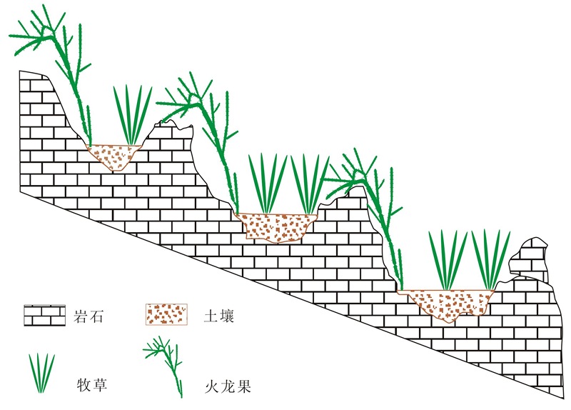
Terraced planting of pitaya and pasture on karst slopes
6 Research and Prevention of Soil Leakage in Karst Peak Cluster Depressions
Sponsored by the scientific projects from the MST, Ministry of Water Resources and the Guangxi Zhuang Autonomous Region, Prof. Jiang Zhongcheng and his research team from the Institute of Karst Geology, CAGS achieved important results in the study of process, dynamic mechanisms and prevention technology of soil and water leakage in karst peak cluster depressions. By using on-site monitoring and advanced isotopic technique, the team firstly and systemically revealed quantitative differences and causes of water leakage and soil erosion in different geomorphologic positions and ecological environments of karst peak cluster depressions, proposed grade classification standards and a regression model of soil erosion in karst areas, created new water and soil conservation models which integrate biological methods with engineering and technological rules, and formed the pitaya ecological production industry with good ecological and economic benefits in a karst rocky desertification environment. All these research results can provide technological support and demonstration examples for the treatment of rocky desertification and conservation of water and soil in karst areas in Southwest China.
7 Theory and Technique of Evaluation and Prognosis of Key Mineral Resources in China
Prof. Xiao Keyan and his team from the Institute of Mineral Resources, CAGS proposed ore deposit modeling and synthetical information methods for mineralization evaluation under the guidance of experts such as Academician Chen Yuchuan and Prof. Ye Tianzhu, and by referring to the experience from both China and abroad. The whole process for mineral resource prognosis method was based on the GIS platform. The evaluation was conducted for 22 key mineral resources, including iron, bauxite, copper, lead, zinc, tungsten, tin, molybdenum, REE, gold, silver, antimony, manganese, chromite, nickel, lithium, magnetite, leopoidite and boron. A database of mineral resource evaluation was built. About 50,000 targets and prospective areas of different kinds and different grades were delineated, from which provincial prospective areas and countrywide prospective areas were selected and inferred resources were evaluated, which has provided important information to the deployment of mineral exploration work in China.

The mineral resource assessment system (MRAS)
8 The Earliest-known Multituberculate Mammal of the Jurassic from Liaoning Province, China
Funded by the MST (Project 973), the ML, the Science and Technology Commission of the Beijing Municipal Government, and by the National Science Foundation of the United States and the University of Chicago, Prof. Ji Qiang and his team discovered a new fossil mammal from 160 million years old beds in Jianchang County of Liaoning Province, China.
The new mammal is named Rugosodon eurasiaticus after the rugose teeth ornamented by numerous tiny ridges and grooves and pits, indicating that it was an omnivore that fed on leaves and seeds of ferns and gymnosperm plants, plus worms and insects. Its ankle bones are surprisingly mobile and flexible, suggesting that Rugosodon was a fast-running and agile mammal. It is also very important that Rugosodon is the earliest-known skeletal fossil of the multituberculates, and through its study paleontologists can trace the evolutionary origins of the versatile and diverse locomotor adaptations of later multituberculates that include tree climbers, ground runners, and digging mammals living underground. This fossil helps to shed light on the earliest evolution of multituberculates, a major group ofextinct mammals that lived in the Mesozoic of dinosaurs and ultimately survived the mass extinction that wiped out dinosaurs 65 million years ago.

欧亚皱纹齿兽复原图
Ecological reconstruction of Rugosodon eurasiaticus
9 The Re-Os Isotope Analytic Technology Offers a New Way for Dating Sedimentary Rock
With the help of the MOST, NNSF and CGS, the research team on Re-Os isotope of NRCGA led by Dr. Qu Wenjun pioneered the research on the analysis method of sulfide Re-Os dating in China, expanded its applications, and achieved remarkable achievements. In the wake of molybdenite dating method, the team successfully developed a range of national first reference materials (such as Cu-Ni sulfide and Co-rich crust). They also improved the sample preparation approaches and high temperature and pressure digestion technologies, established the Re-Os analysis procedure and dating methods suitable to pyrite, arsenopyrite, limestone, graphite, bitumen and other low Re-Os content samples. The main technical indicators of this lab, such as the procedure blank, accuracy and precision, have reached international advanced levels. Their work has provided a way for dating sedimentary rock, hydrocarbon source rock and oil-gas reservoirs.

铼-锇同位素分析测试
Re-Os isotopic dating analysis
10 Important Progress in the Pre-Mesozoic Tectonic Evolution of the Alxa Block, Xinjiang
A combined detrital zircon U-Pb geochronology and Hf isotopes and paleomagnetic study on the Late Devonian-Middle Triassic strata was carried out by the research group headed by Dr. Yang Zhenyu of the Key Laboratory of Paleomagnetism and Tectonic Reconstruction, MLR in the Institute of Geomechanics. The finding results indicate that the detrital zircons cover five age populations: 0.4–0.7 Ga (peak at 488 Ma); 1.0–1.3 Ga (peaks at 1001 and 1152 Ma); 1.5–1.8 Ga; 2.4–2.8 Ga (prominent peak at 2506 Ma and secondary peaks at 2668 and 2796 Ma); and >3.0 Ga (peak at 3332 Ma). Zircons with U-Pb age spectra of 2.4–2.7 and >3.0 Ga and their corresponding εHf(t) values are significantly different from those in the NCB, indicating that these detrital zircons are not from the NCB, which implies that the Alxa terrane was not part of north China until the Middle to Late Devonian. Paleomagnetic results yielded from the early Carboniferous limestones and the Late Permian purple sandstones sampled in the eastern Alxa terrane (ALT), northwest China indicate that the apparent polar wander path (including early Carboniferous, late Carboniferous-Early Permian, Late Permian and Early-middle Triassic poles) is significantly different from those of the NCB. If the APWP of Hexi Corridor-Alxa rotated counterclockwise by 32° around the Euler pole at 44°N, 84°E, then the coeval APW path of the ALT overlaps that of the NCB. This result indicates that the ALT migrated to the NCB after the Early-Middle Triassic along a tectonic boundary between the Helanshan Mountains and Zhuozishan Mountains, and finally amalgamated to the NCB before the Early Cretaceous. The result provides basic data that will deeply strengthen our consideration on the Mesozoic tectonic evolution of northern China.

Reconstruction of the Late Triassic Paleogeography