Science & Technology
Top Ten Advances in Science and Technology of Chinese Academy of Geological Sciences in 2012
On January 10 and 11, 2013, the Annual Meeting of Achievement Exchange and Selection and Appraisal of Top Ten Scientific Advances of 2012 was held in Beijing by Chinese Academy of Geological Sciences (CAGS). The judging panel is composed of 54 academicians and 39 experts fromthe Ministry of Land and Resources, the Ministry of Education, Chinese Academy of Sciences, National Natural Science Foundation, China Earthquake Administration, and Sinopec Group, etc. The top ten advances in science and technology came out after careful and rigorous review and vote.
Special Advance:Project SinoProbe advances in step withthe international level
Sponsored by the Ministry of Finance and the Ministry of Science and Technology and organized by the Ministry of Land and Resources, the SinoProbe team led by Researcher Dong Shuwen and Academician Li Tingdong of Chinese Academy of Geological Sciences (CAGS) has completed 6000km deep seismic reflection profiles, making China an international power of deep exploration, and established the national magnetotelluric parameter network and geochemistry standard network. Important discoveries were obtained in 6 drilling holes of scientific placement, realizing 3D detection of ore-concentrated areas. Progress has been made in in-situ stress monitoring of key areas, dynamics simulation of lithosphere and research on structure and evolution of continental crust. Development of detection instruments has made a significant breakthrough. SinoProbe is thought to be a symbolically significant earth sciences plan, indicating that China has become a geological power. SinoProbe has imposed great influence on international earth sciences with its economic and social significance and great innovative value. It is a beneficial exploration to the organization and implementation of great scientific plan and provides a basis for implementation of ‘Earthcrust Exploration Project”. SinoProbe was rated as “One of the Top Ten Advances in Science and Technology of China in 2011” by academicians of the Chinese Academy of Sciences and Chinese Academy of Engineering.
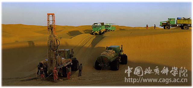
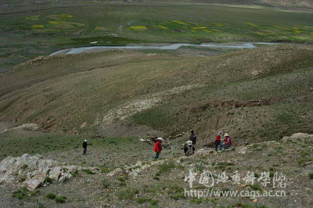
Seismic exploration in desert
Ten Advances in Science and Technology in 2012:
1.The world’s first 1:5,000,000 digital Asian geologic map
The digital 1:5,000,000 Asian Geologic Map compiled by the team led by Chinese geologists has received high evaluation.
Sponsored by the geological survey program, the team led by Academician Ren Jishun of the Institute of Geology has compiled 1:5,000,000 Asian Geological Map with over 130 scientists from 20 counties across Europe and Asia within the past 7 years, and has built a spatial database of geological maps on the ArcGIS platform according to the resolution of the Commission for the Geological Map of the World (CGMW). The map covers a range from the Alps in the west to the Marianna Trench in the east and from the Arctic Ocean in the north to the Java Trench in the south, including the Asian mainland, most of Europe, East Africa, Northeastern Australia, Philippine Sea, Northern Indian Ocean and a part of West Pacific. The International Review Committee acknowledged that the 1:5,000,000 Asian Geologic Map is a masterpiece of modern geological mapping and a significant milestone.
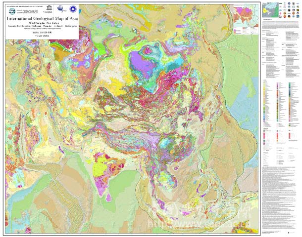
1:5,000,000 Asian Geologic Map
2. Hf isotope mapping indicating crust growth and mineralization in the southern Tibetan Plateau
The new technology of Hf isotope tracing is applied to indicate lithosphere structure, crust growth and ore-controlling role in the southern Tibetan Plateau, implying significant progress. Sponsored by the National Key Basic Research and Development Plan of China (973 Program), the team led by Researcher Hou Zengqian of the Institute of Geology discovered through Hf isotope mapping that the central part of the Lhasa terrain is composed of Precambrian micro-continents and that both sides of the Lhasa terrain are juvenile crust with injected mantle-derived material. The source of ore-forming metals and ore deposits distribution are evidently controlled by vertical and lateral accretion of micro-continents caused by the Tethys subduction orogeny and collision between the Indian and Asia continents. The porphyry copper deposit occurs in the Cenozoic lower crust.The skarn iron-copper deposit is developed in the interior continent and the reconstruction edge. The Pb-Zn deposit is developed in the residual interior and the edge of the micro-continents. Thus, the understanding about metallogenetic law in collisional orogenic belt is deepened.
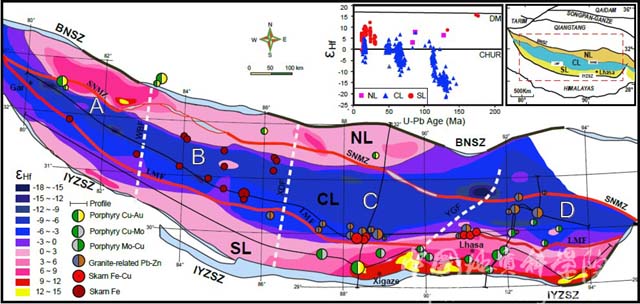
Hf isotope mapping and metallogenic system
distribution in southern Tibet Plateau
3.Fruitful achievements of palaeo-environment reconstruction and metallogenesis researchin the Qaidam Basin
Scientific drilling in the Qaidam Basin reveals palaeoenvironment change and metallogenesis process. Jointly sponsored by the geological survey program and Natural Science Foundation of China, the team led by Academician Zheng Mianping of the Institute of Mineral Resources obtained high precision chronological data and high resolution palaeoenvironmental record 1.17Ma ago in the eastern Qaidam Basin, indicating cool-and-warm or slight warm-and-wet palaeoenvironment over 1Ma before the late Late Pleistocene. Fifteen periods of cold period deposits with strong winter monsoon are developed in the early Quaternary in the western Qaidam Basin. The key boundary of winter monsoon and summer monsoon and the middle Qaidam Basin salt-forming zone are discovered in the middle Qaidam Basin. The team defined the Qarham sylvite-bearing deposit, presented multi-salt basin migration and potassium formation in a high mountain-deep basin, and analyzed genesis and controlling factors of Quaternary biogas in the Sanhu Area, providing an important basis for the evaluation of sources in the Qaidam Basin.
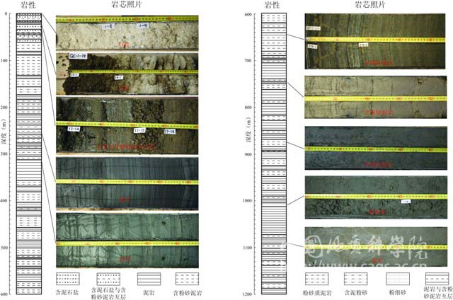
Sketch of QC-1 Core of the first full coring deep hole in Qarhan Salt Lake of Qaidam
4.Innovative development of research on metamorphism and tectonic evolution in the southern Tibet Plateau
Sponsored by the geological survey program, the team led by Researcher Zhang Zeming and Assistant Researcher Dong Xi of the State Key Laboratory of Continental Tectonics and Dynamics of the Institute of Geology has made progress in research on metamorphism and tectonic evolution of the Lhasa terrain. First, the team discovered high pressure granulite about 650Ma ago in the northern area and identified Triassic metamorphic rock in the middle area, which was thought to be a Precambrian basement. Second, the team discovered high temperature, high pressure and high oxidation degree adakitic Late Cretaceous charnockite in the southeastern terrain, and determined that Mesozoic and Cenozoic high-grade metamorphic rock associated with Gangdise batholith and the middle and lower crust which constitute magmatic arc with intrusive body in the southern area. Third, the team clarified the evolution history of the Anduo block in the northern terrain from Neoproterozoic to Jurassic and revealed Paleoproterozoic and Eopaleozoic magmametamorphism event in the Namcha Barwa metamorphic series. The above achievements help clarify the metamorphic evolution history and ore-forming condition of the Lhasa terrain and have been published in leading international geological journals, which are highly quoted.
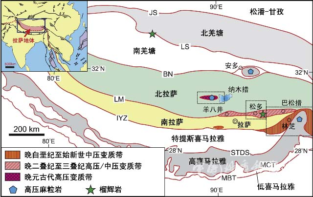
Metamorphic geological map of the Lhasa terrain in the Tibet Plateau
5.Discovery of a new diamond enrichment type---ophiolite diamond
Jointly sponsored by the Ministry of Science and Technology, Natural Science Foundation of China and geological survey program, the pyrolite research team led by Researcher Yang Jingsui of the State Key Laboratory of Continental Tectonics and Dynamics of the Institute of Geology has discovered high pressure minerals such as Myitkyina mantle and Dingqing mantle peridotite in the western part of the Brahmaputra River and Burma, and diamond of the Sartokay Chromite deposit. The research team has discovered deep minerals like diamond in 10 ophiolite rock masses in 5 suture zones all over the world and in-situ diamond in chromite.The C isotope and mineral inclusions differ from that of kimberlite diamond and ultrahigh pressure metamorphic diamond. Therefore, this new type of diamond in ophiolite mantle peridotite was defined and named ophiolite diamond, which provides anew direction of diamond exploration.
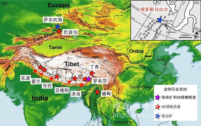
Distribution of ophiolite diamond
6. Electromagnetic wave detection and tomographic imaging system with well-to-well spacing of 500m
Large penetration distance underground electromagnetic wave detection and tomographic imaging system of independent research and development has reached the international advanced level. Sponsored by National High Technology Research and Development Program of China (863 Program), the team led by Researcher Gao Wenli of the Institute of Geophysical and Geochemical Exploration made a series of breakthroughs in low frequency-big power emission, high sensitivity receiving, and down hole antenna technique.The team developed a underground data acquisition system among drill holes and underground tunnels, and scientific research prototype with associated data interpretation system, forming a great penetration distance underground electromagnetic wave tomographic imaging system with proprietary intellectual property right. Test shows that the system has stability and well-to-well detection range of over 500m and can detect blind ores and karst caves, providing high resolution equipment for geological exploration.

Underground electromagnetic wave data acquisition system
7.Multielement morphological analysis technique showing promising prospect of application in eco-environmental geochemistry
Morphological analysis technique of beneficial elements and harmful elements like bromine,iodine,arsenic,and cadmium opens a new field of element geochemistry analysis. Sponsored by the Natural Science Foundation of China, the public welfare special project and geological survey program, Researcher Li Bing of the National Research Center for Geoanalysis applied HPLC-ICP-MS and established analysis technique and method system of element valence state,metallo-organic compound,and biological effective morphology,including high-quality spring water bromate measurement technique, iodine geochemical survey method,biological sample arsenic morphological analysis technique, plant sample cadmium morphological analysis method.With high sensitivity and low detection limit, the analysis technique and method system provides important technical support in experiment and test for ecological geochemistry survey and environment evaluation.
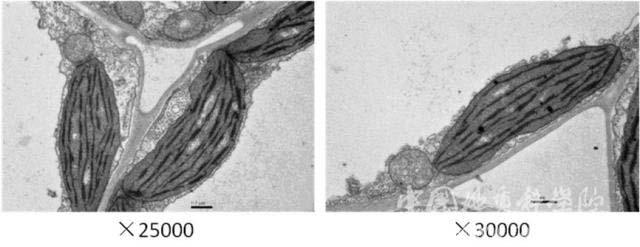
The impact of cadmium stress on ultrastructure of brassica juncea cells
8. A major breakthrough in prospecting of the Tibet Garjoan Cu-Au deposit
With scientific and technical advantage and careful ore prospecting, a large Cu-Au deposit was discovered in Garjoan, Tibet. Jointly sponsored by the public welfare scientific research special project and commercial exploration program,the team led by Researcher Tang Juxing of the Institute of Mineral Resources defined the Garjoan Cu-Au deposit, studied mineralization regularity, and discovered special metallic minerals such as osmium-bearing native bismuth, S-Se bismuthide,Te-Se bismuthide,native iron, Zn-Cu intermetallic compound, and Fe-Cr-Ni intermetallic compound.The team also defined the deposit type and established a deposit model. The Garjoan Cu-Au deposit is the first large Cu-Au deposit which has reached the detailed survey level intheBangong-Nujiang suture zone and its 332+333 copper resource is 87,000 tons,inter grown gold resource 27 tons, and associated silver resource 52 tons, which is a major breakthrough in scientific prospecting.
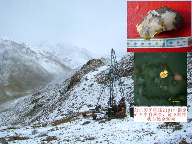
Garjoan ore district
9. Achievements of research on the Jurassic-Cretaceous boundary and marine-continental stratigraphic correlation
Sponsored by the geological survey program,the team led by Researcher Jiqiang and Liu Yongqing of the Institute of Geology conducted research on stratigraphic sections of 9 marine Jurassic-Cretaceous boundaries in South Tibet and 7 continental boundaries in western Liaoning and obtained an age of 142Ma at the bottom of Sangxiu Formation in South Tibet, which suggests that the international Jurassic-Cretaceous boundary age isnot younger than 142Ma and supports the boundary age of 145Ma put forward by the International Commission on Stratigraphy.The team obtained ages of 154Ma and 137Ma at the bottom and top of the Tuchengzi Formation in the north Hebei-west Liaoning area respectively, which suggests that the Jurassic-Cretaceous boundary is inside the Tuchengzi Formation.The team considered that the marine Jurassic-Cretaceous boundary in South tibet is located between the Rouzha Formation and the Sangxiu Formation or the Jiabula Formation, and that the continental Jurassic-Cretaceous boundary in western Liaoning is located between Member 2 and Member 3 of the Tuchengzi Formation, i.e. The bottom of the Euestheria-Ephemeropsis trisetalis interval-zone. This ends the long-term dispute on the Jurassic-Cretaceous boundary and stratigraphic correlation of the marine-continental boundary.
The Kadongqiao Jurassic-Cretaceous boundary profile in Nagarze, Tibet
10. Deep dynamic process and tectonic-magmatic genesis system of the middle and lower reaches of the Yangtze River revealed by seismic exploration
Jointly sponsored by the Sinoprobe-3 and Natural Science Foundation of China, the team led by Researcher Lü Qingtian of the Institute of Mineral Resources obtained key information of deep dynamic process of the mineralization zone in the middle and lower reaches of the Yangtze River with the active source and passive source seismic survey technique. The team discovered anomalous velocity and anisotropy texture in the upper mantle and “crocodile mouth” structure in the earth crust near faults at the edge of mineralization zones,i.e. upper earth crust thrusts, lower earth crust underthrusts and penetrates Moho all the way to the top of the upper mantle. The team also discovered that the reflection event density is in direct proportion to volcanicity intensity and that there are reflection anisotropy and seismic traces left by multistage magmation below the Luzong volcanics basin.The team discovered inhomogeneity of earth crust deformation and obtained new evidence of interaction between earth crust deformation and magmation. The team put forward deep formation process of
intracontinental giant mineralization zone and tectonomagmatic system model, i.e. intracontinental subduction accretion,lithosphere delamination, mafic magma underplating,juvenile crust fusing with MASH process, and illustrated genesis of the intracontinental giant mineralization zone.
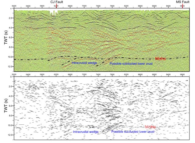
Reflection seismic migration profile of the Ningwu ore-concentrated area
The top ten advances in science and technology of the Chinese Academy of Geological Sciences (CAGS) in 2012 came from 22 excellent programs selected and recommended by the CAGS affiliates among 1025 executed programs, represent the latest research level and received great attention and favorable comments from academicians and experts. Academician Li Tingdong spoke highly of the fruitful achievements and innovative ideas with remarkable benefits and outstanding contributions. (1)The achievements involve numerousdisciplines,covering almost all subjects and fields in the researches of the CAGS; (2)The undertaken programs have diversified sources, including national special scientific and technological projects, National Basic Research Program of China (973 Program), National High Technology Research and Development Program of China (863 Program), National Natural Science Foundation of China, public welfare scientific research special projects, geological survey programs, and some other sources; (3)The undertaken research projects touch upon a wide range of areas, including various regionsin China,the Asian continentand adjacent sea areas; (4)The achievements have reached a high level with many important findings and new ideas; (5) The achievements have brought about promising social and economic benefits, which are favorable to the development of China.
Chinese Academy of Geological Sciences
January 11, 2013