Research Institutes
Major Research Achievements
Major Research Achievements Of 2013
(1) Application and promotion of high-power multi-functional electromagnetic system and multifrequency
array phase IP system: Clear IP and CSAMT anomalies were obtained by adopting the domestic multi-functional electromagnetic measuring system in the lead-zinc mining area in Xiyi
Village, Baoshan City, Yunnan Province, where the metallogenic geological background and tectonics
are complicated in addition to humanity’s electromagnetic noises and carbon disturbance. These
anomalies indicate deep prospecting potential and are of important guiding significance for further ore
prospecting in this area. The controlled-source CSAMT yielded good results in the copper mining area
in the Duobaoshan Town. Not only characteristics of the copper orebody at a depth of 1300 m was
revealed, but also new clear prospecting targets were discovered at deeper layers and on the sides of the
known ore.
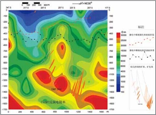
Compound interpretive diagram of electrical survey in the Duobaoshan Copper Deposit, Heilongjiang Province
(2) Development and application demonstration of measuring technique of UAV-based airborne geophysical prospecting (airborne electromagnetic/ airborne magnetic/airborne radioactive) system: The world’s first prototype of comprehensive UAVbased airborne geophysical prospecting measurement system (airborne magnetic/airborne radioactive) was developed and its application testing was carried out successfully. Core technologies such as aerodynamic configuration, electromagnetic compatibility, telemetry and telecontrol were developed.
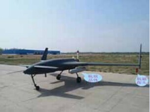
CH-3 UAV-based Airborne Geophysical Prospecting (airborne magnetic/airborne radioactive) Integrated Station “航放晶体” in the picture stands for Crystal for airborne radioactive survey and “航磁探 头” for Sonde for airborne magnetic survey
(3) Development of a high-precision gravity and magnetic instrument and application of hightemperature
superconducting technology: Based on the advances in technologies of measuring systems such as quartz spring sensitive components, a prototype of the high-precision gravimeter was developed, which filled in a gap in China. The amplitude-phase instrument was widely applied, so as to make a contribution to the promotion of using new technology.
(4) Development of high-accuracy tri-component borehole magnetometer: The high-accuracy tricomponent
borehole magnetometer was successfully developed to increase the logging depth to 2,000 m
and the measurement accuracy was significantly improved in comparison with the instruments of its type
used in China. It can be used in exploration for deep ore bodies with strong and moderate magnetism
and will be hopefully commercialized in the future.
(5) Development of small-bore multi-parameter deep logging system and borehole array IP
observation system: This is an array borehole-surface and surface-borehole IP observation system and
the corresponding 3D data processing and explanation software is also developed.
(6) Demonstration of 3D graphic system of geological mapping in integrated geophysical exploration in major metallogenic belts in the middle and lower reaches of the Yangtze River: The research group developed a visualization system for 3D geological mapping based on 3D geological modeling technique and 3D geological structure rendering function of MapGIS K9.
(7) Integration of regional geophysical survey results, development of geophysical methods and
techniques and regional geochemical survey in ore-forming belts: The research groups developed
much-needed methods and techniques for regional geophysical and geochemical exploration. They
organized and participated in the national regional geophysical survey in ore-forming belts, carried out
nationwide regional geochemical reconnaissance program, and compiled basic geophysical maps of
major ore-forming areas and belts.
(8) Regional geochemical exploration demonstration of maneuvered drilling in shallow covered areas in the East Tianshan metallogenic belt: A shallow-drilling geochemical system applicable to shallow-covered areas was developed for different exploration levels: investigation, reconnaissance and detailed exploration, which has been effectively applied to various types of shallow-covered areas in Xinjiang, Gansu and Anhui, and located geochemical anomalies of polymetallic or iron-family elements related to bedrock or mineral deposits. It has provided technological support to geochemical prospecting and evaluation of mineral resources in shallow-covered areas of more than 1,500,000 km2 in China.
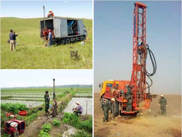
A site of geochemical sampling with maneuvered drilling in a shallow covered area